

The Eastern Sierra offers some of the most scenic hiking trails in the country—one of its popular day hikes, Lone Pine Lake, follows the same trail as Mount Whitney (the highest mountain in the contiguous United States) without the same strenuity. On this trail, you'll find mountain streams, pine forests, dramatic peaks, granite cliffs, and an alpine lake. This guide will detail everything you need to know to plan your visit.
Quick Facts About Lone Pine Lake
• Distance: 6 miles out-and-back
• Time: 3 to 4 hours
• Difficulty: Moderate
• Elevation gain: 1,771 ft.
• Fees and permits: None
• Trailhead address: Mt. Whitney Trailhead, Whitney Portal Road, Lone Pine, CA 93545

Parking at the Lone Pine Lake Trailhead
Use this map to locate designated parking areas. Note that Whitney Portal Road (the only road to the trailhead) is typically closed after the first major winter storm of the year until late April to early May—seasonal road closures will tack on an additional three miles to your hike.

When to Visit Lone Pine Lake
The best time to visit Lone Pine Lake is between late April until October:
• Spring (April-May): During spring, you'll likely encounter lingering snow and a frozen lake. We visited during late April and found the cool weather to be optimal for hiking the trail.
• Summer (June-August): Summer is a popular time to visit as the lake is no longer frozen over—I recommend starting your hike early as sections of the trail have no shade.
• Fall (September-October): While you can expect cool weather during this time of year, snow in October is not unusual.
• Winter (November-March): Depending on snow conditions, the trail may still be accessible with the appropriate gear. Pack your crampons or microspikes in case!

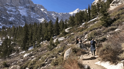
Hiking to Lone Pine Lake
The trail begins at a starting elevation of over 8,300 ft. As you begin your hike, you'll quickly notice that a majority of the trail is made up of gradual switchbacks. The ascent may be challenging for those not easily acclimatized to the high elevation. The exposed switchbacks offer panoramic views of Owens Valley and Sierra Nevada mountain peaks.
During the ascent, you’ll cross two streams, Carillon Creek and North Fork of Lone Pine Creek—trekking poles are helpful but not necessary to pass through the creeks. After crossing the latter, you’ll see a “John Muir Wilderness” sign where you'll continue along more switchbacks before reaching a pine forest. Here you’ll cross a log bridge over Lone Pine Creek. Once you reach the Lone Pine Lake junction, turn left and head downhill toward the lake.
And... you made it! Walk the perimeter of the lake for views of the surrounding peaks, granite cliffs, and valley floor.
Download the AllTrails map here.


